Sunday, October 16, 2016

Another Rail Bridge: People Living the Creek

I was at this location a year ago.  Unfortunately, I lost my phone with all the pictures and videos before I could produce a post.

Jackson Creek was lucky enough to flow, where there's now a junction of a rail line and a power transmission corridor.


This section of shrub-land may also see some  transformation, being in the cross-hairs for GO Transit as a station.

There are two channels on the lot that reflects the former course of the creek in 1947.  It seems that the creek was switching back and forth between the beds.


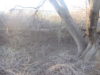
The east channel is full of quite old trees.  Stepping down (5-6 feet) seemingly transports you to any tract of York Regional Forest.

Looking over the dry channel facing East Mall
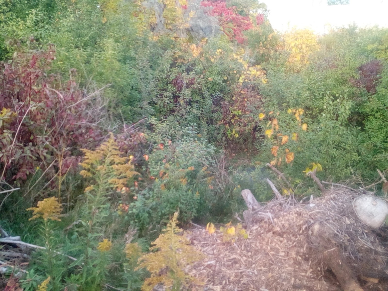
Since the last time I was there, the West channel got taken over by blackberry thorn-brush and grapevines.


The biggest change was the absence of mini lake/ wetland that was right below the culvert where the creek used to come out. There are still remnant of a pretty awesome dock that was there.  The dock is a strong evidence of a need for more green-space/ natural heritage for people to interact with.  It is somewhat clandestine, but since the city does not provide by collaborating with wiping out of entire ecosystems and turning South Etobicoke into a concrete post-industrial jungle, then who can blame the developers of the dock.  Plus they kept it super tidy.


The lack of water certainly surprised me.  Of what I remembered too, was that you could see through the culvert to the other side.  I was assuming that it was to some sort of vertical drain at the Food Basics/ Metro property across.  


WARNING  While it is a popular local practice to cross and use this rail line for pedestrian purposes, the tracks are still used for freight and a limited GO Service.

I carefully went across the lines in the name of science and conservationism.  To my surprise, I discovered a bridge, much like the one at Horner.  However this one is in much better condition and seemed to be freshly excavated. 

I was about to jump down, but a friend of Jackson Creek, Greg (name changed), popped out from under.  He admitted to live there, yet did not seem too talkative.  Since no one likes to be an uninvited guest, I wished him to have a nice day and started to track back, as the sun was setting. 


Below is some sort of industrial facility, now decommissioned and for lease.  


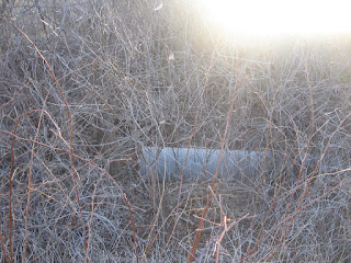
At the East Mall end of the lot lies a manhole that may shield the waters of the creek being piped away.


It is nice to see a culvert, a bridge and a bed still being preserved.  Just add water and everyone may enjoy new access to the outdoors and the special experience of watching living water flow.  Well, maybe not Greg. 


Please join the movement and contribute at https://friendsofjacksoncreek.slack.com/home 


Update: I managed to recover pictures from my earlier vision.  That was before Greg capped the culvert.  


Thursday, October 13, 2016

Spectacular Find: A Bridge and Silt off Jackson Creek Frozen in Time

RANT

Gotta love Rail Roads!

They are ancient, they are fossils, they fascinate antisocial introverts that hoard related memorabilia, they are great for political corruption, and so on...

If we lived in a sane society, all rail would be converted into cute trails (2). However, rail is old money and a huge monopoly.   The stakeholders are literally in bed with the govt and it is a cause for concern.

You may say, but muh public transpo.  Yes, there's a case to be made re modern high speed rail.  But all we have is this.

Above ground heavy rail has no place in the city.  Besides the obvious safety concern to humans via accidents and dangerous contents, rail divides neighbourhoods, creates extra pollution via cars constantly using the under/over paths, rob scarce land and so on.  Even with a modern high speed rail, the terminals ought to be way out of the even future development, much like the airports, not running through downtowns, like it is still 1800's.

The point of the rant is that CANPA spur must be decommissioned into a trailway and a future path for Jackson Creek.

NOTE! Even though this spur is everything but decommissioned, very rarely trains do use it, such as in GO Transit emergencies.  Be super careful.  In any case, never trespass onto the Lakeshore Line.  Trains move fast and it is plain stupid.


BACKGROUND

Knowing that Canpa is not fully maintained and in a gradual state of decommission, I wondered if there was some culvert/ dry bed around the track to revive the day-lit Jackson Creek.  

I consulted my trusty aerial photos of Toronto (Google Maps Satellite of Yesteryear).  Of interest was that one of the parks along the course was a quarry of some sort.

Unfortunately, the crossing was at the juncture with the maintained and very live Lakeshore Corridor.  Not expecting much, I set out to snoop for any trace of the unfortunate creek.


It looks like that the development caught up with the place in late 60's and the flow stopped there and then. 

FIELDWORK

While in the neighbourhood, I noticed old, large colonies of invasive American Bamboo.  You never find these, for example under power-lines, as these, in our parts, spread via streams breaking off roots/etc and bringing that to a new bed downstream.  These plants definitely remember Jackson Creek.


Just a few steps from Horner Ave, I could not believe my luck.  Not a culvert, not a filled in concrete iceberg sticking out, but an actual fossil of the former creek's glory!


I could not resist, but enter it.  Walking on some 50-year-old silt deposited by a living, pulsating steam of water full of tadpoles and minnows, maybe some water spiders was a profoundly sad experience.  What a senseless loss and poor development.  


Mixed with silt were some human artefacts.  What is curious is that one side of the bridge is inscribed with 1902 and the other with 1910.  Did someone overlook something or perhaps the bridge took 2 years to build?...


Downstream is paradoxically a pipe-making or maybe rather selling facility.  I kid you not.


They have done some serious infilling.  Also a rather smaller pipe/ culvert goes somewhere under the property.  I am sure it is clogged or crushed under the weight of the pipes and equipment.  

Also coming in is a still smaller culvert from Horner. 


On the other side of the commercial property, there are 3 conspicuous manhole covers in a chain diagonally across the Towns Rd.  You can hear rushing water under them.  Curiously one of them says Sanitary Sewer (gross).  But the other two say Stormwarter Sewer, suggesting false advertisement on the 1st's part. Local historians note that the creeks got stolen from us by the city piping them out into drains that follow their courses.  


Now my vision is to restore Jackson Creek exactly to the original course.  That is how it was for millions of years and the water by trial and error (note the winding paths on the aerial maps) optimised it way to the lake.  However, rather than interfering with the commercial operations of the pipes plant, etc, it may be proper to send Jackson Creek beside the decommissioned Canpa and the trail.  The ditch there is quite deep and is full of riparian cat tails. It seems like a perfect new bed.  Just add water.  Maybe even make a pond there, before connecting it to the string of parks that were once parts of the watercourse below.  


Afterwards, the poor dead waters of the creek are taken via Kipling radial sewer down to Lakeshore and then dumped into lake at various points. 


Some of it is dumped into Etobicoke Creek, just before the municipal beach that is the second dirties spot on Lake Ontario, as per my previous points.  Heck, they want to move that beach to the foot of Kipling, where daylit North Creek together with a terminal marsh displays a much more responsible aquatic husbandry. Of note is that the dirties spot on Lake Ontario is Sunnyside Beach on lake Ontario, where the headwaters of Jackson Creek are dumped.


Upstream, there is a clear depression across Firma Crescent.  On the west side, there are remains of a former bridge stricture and a corresponding manhole cover on the east side.  There's a pipe coming out into a channel that was made for the creek waters.

Fima Road in the back, sidewalk and railing in the mid-section and channel in the foreground
Sidewalk and railing

Peeling back the grapevine
The gap between the two buildings is filled with some sort of weatherproof structure now.  But it is accessible from the other side.  There, the owners were nice enough to leave the former channel of the stream intact, running parallel to Fima Rd.  All is connected by the same type of metal pipe.  


Water is a persistent element and the recent rain flow showed exactly where the water would have gone. 


On Horner exists a clear depression, where the creek have been flowing.  It is also emphasised  by double storm sewer grate and a manhole cover that produces strong sounds of rushing water from underneath.  
There's also a characteristic dip on the grounds on the north side
The commercial property from the north side also sports a ditch on the west side of the building.


Thanks for reading, please claim this movement by joining the conversation on Slack.